
Heathcote topographic map
Click on the map to display elevation.
About this map
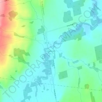
Name: Heathcote topographic map, elevation, terrain.
Average elevation: 259 m
Minimum elevation: 223 m
Maximum elevation: 367 m
Grey County trails, hiking, mountain biking, running and outdoor activities
Other topographic maps
Click on a map to view its topography, its elevation and its terrain.
Pretty River Valley Provincial Park
Canada > Ontario > Grey County > The Blue Mountains
Average elevation: 418 m
Craigleith Provincial Park
Canada > Ontario > Grey County > The Blue Mountains
Average elevation: 215 m