Geolocate

Rhineland topographic map

Click on the map to display elevation.

About this map

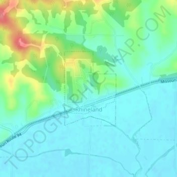
Name: Rhineland topographic map, elevation, terrain.

Location: Rhineland, Montgomery County, Missouri, United States (38.71497 -91.52215 38.72635 -91.51208)

Average elevation: 172 m

Minimum elevation: 152 m

Maximum elevation: 228 m

Other topographic maps

Click on a map to view its topography, its elevation and its terrain.

Bluffton

United States > Missouri > Montgomery County

Average elevation: 185 m

Gear up for your next adventure:

🧭Orienteering Kit - Tools for map reading and navigation in the wild
🧥Thermal Fleece Jacket - Versatile insulation for changing mountain temperatures
🧰Survival Kit - Essential gear for emergencies in the wilderness
🥾Hiking Gaiters - Protect legs and shoes from mud, snow, and debris
🛏️Camping Sleeping Mat - Comfortable mats for sleeping outdoors

As an Amazon Associate, this site earns from qualifying purchases at no extra cost to you.