
Dublin topographic map
Interactive map
Click on the map to display elevation.
About this map
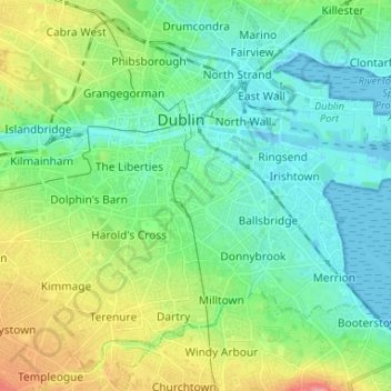
Name: Dublin topographic map, elevation, terrain.
Location: Dublin, Dún Laoghaire-Rathdown, Dublin 2, Leinster, Irlande (53.30193 -6.30830 53.36619 -6.17732)
Average elevation: 23 m
Minimum elevation: -2 m
Maximum elevation: 81 m
Other topographic maps
Click on a map to view its topography, its elevation and its terrain.
Cherry Orchard
Cherry Orchard, Merchants Quay E ED, Dublin 8, Dublin, County Dublin, Leinster, Irlande
Average elevation: 25 m