Geolocate

Darga topographic map

Click on the map to display elevation.

About this map

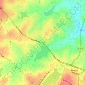
Name: Darga topographic map, elevation, terrain.

Location: Darga, Hosur, Krishnagiri, Tamil Nadu, 635109, India (12.72595 77.79532 12.76595 77.83532)

Average elevation: 869 m

Minimum elevation: 834 m

Maximum elevation: 900 m

Gear up for your next adventure:

🐕Hiking Dog Pack - Let your canine companion carry their own water and food
🥾Hiking Shorts - Breathable shorts suitable for summer hikes
🧥Waterproof Jacket - Lightweight rain jackets for hiking and outdoor activities
Tent Footprint - Protect tent floor and increase durability
🥾Trail Hiking Boots - Supportive boots for rough trails

As an Amazon Associate, this site earns from qualifying purchases at no extra cost to you.