
Make a donation
Gear up for your next adventure:
As an Amazon Associate, this site earns from qualifying purchases at no extra cost to you.
Cham topographic map
Click on the map to display elevation.
Make a donation
Gear up for your next adventure:
As an Amazon Associate, this site earns from qualifying purchases at no extra cost to you.
Cham
Die Anzahl der männlichen übersteigt die Anzahl der weiblichen Beschäftigten deutlich. Der Grund dafür ist die höhere Erwerbsquote unter den Männern. Eine klar überwiegende Mehrheit der Teilzeitarbeitsverhältnisse werden von Frauen besetzt.
Make a donation
Gear up for your next adventure:
As an Amazon Associate, this site earns from qualifying purchases at no extra cost to you.
About this map
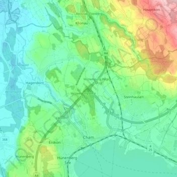
Name: Cham topographic map, elevation, terrain.
Location: Cham, Zug, Schweiz (47.16743 8.41483 47.23377 8.47990)
Average elevation: 440 m
Minimum elevation: 384 m
Maximum elevation: 591 m
Make a donation
Gear up for your next adventure:
As an Amazon Associate, this site earns from qualifying purchases at no extra cost to you.
Other topographic maps
Click on a map to view its topography, its elevation and its terrain.
Make a donation
Gear up for your next adventure:
As an Amazon Associate, this site earns from qualifying purchases at no extra cost to you.
Make a donation
Gear up for your next adventure:
As an Amazon Associate, this site earns from qualifying purchases at no extra cost to you.