

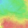
Adobes topographic map
Click on the map to display elevation.
About this map

Name: Adobes topographic map, elevation, terrain.
Average elevation: 1,419 m
Minimum elevation: 1,247 m
Maximum elevation: 1,632 m
Other topographic maps
Click on a map to view its topography, its elevation and its terrain.

Mojón Alto
España > Castilla-La Mancha > Señorío de Molina > Rueda de la Sierra
Average elevation: 1,269 m

Laguna del Rubio
España > Castilla-La Mancha > Señorío de Molina > Campillo de Dueñas
Average elevation: 1,148 m


