
Parque Santa Rosa topographic map
Click on the map to display elevation.
About this map
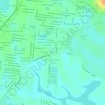
Name: Parque Santa Rosa topographic map, elevation, terrain.
Average elevation: 11 m
Minimum elevation: 0 m
Maximum elevation: 37 m
Other topographic maps
Click on a map to view its topography, its elevation and its terrain.
Praça Cilenio Cesar Terra
Brasil > Rio de Janeiro > Campos dos Goytacazes > Travessão
Average elevation: 25 m
Vila Nova de Campos
Brasil > Rio de Janeiro > Campos dos Goytacazes > Vila Nova de Campos
Average elevation: 64 m
Santo Amaro de Campos
Brasil > Rio de Janeiro > Campos dos Goytacazes > Santo Amaro de Campos
Average elevation: 3 m
Pitangueiras
Brasil > Rio de Janeiro > Campos dos Goytacazes > Santo Amaro de Campos
Average elevation: 3 m