
El Rincón topographic map
Interactive map
Click on the map to display elevation.
About this map
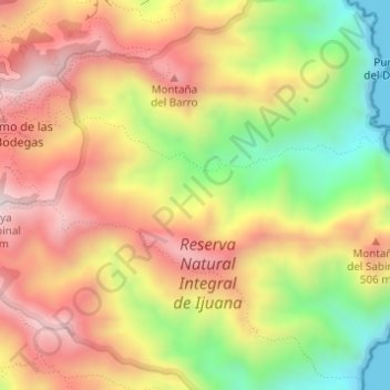
Name: El Rincón topographic map, elevation, terrain.
Location: El Rincón, Santa Cruz de Tenerife, Canary Islands, Spain (28.55700 -16.14101 28.56052 -16.14014)
Average elevation: 342 m
Minimum elevation: 0 m
Maximum elevation: 633 m
Other topographic maps
Click on a map to view its topography, its elevation and its terrain.
La Florida
Spain > Canary Islands > Santa Cruz de Tenerife
La Florida, Santa Cruz de Tenerife, Canary Islands, 38120, Spain
Average elevation: 87 m
Macizo de Anaga
Spain > Canary Islands > Santa Cruz de Tenerife
Macizo de Anaga, Santa Cruz de Tenerife, Canary Islands, Spain
Average elevation: 201 m