Geolocate

Cercido topographic map

Click on the map to display elevation.

About this map

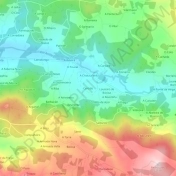
Name: Cercido topographic map, elevation, terrain.

Location: Cercido, Erboedo, A Laracha, Bergantiños, A Coruña, Galicia, Spain (43.21377 -8.53041 43.25377 -8.49041)

Average elevation: 300 m

Minimum elevation: 167 m

Maximum elevation: 514 m

Other topographic maps

Click on a map to view its topography, its elevation and its terrain.

Laxe

Spain > Galicia > Bergantiños

Average elevation: 112 m

Soesto

Spain > Galicia > Bergantiños > Laxe

Average elevation: 75 m

Coristanco

Spain > Galicia > Bergantiños

Average elevation: 252 m

Pazos

Spain > Galicia > Bergantiños > Ponteceso

Average elevation: 94 m

Cabana de Bergantiños

Spain > Galicia > Bergantiños

Average elevation: 169 m

Gear up for your next adventure:

🧣Evaporative Cooling Towel - Beat the heat during intense summer climbs
🛶Canoe Life Vest - Safety vest for water sports
💧Reusable Water Bottle - Durable water bottles for hydration on trails
🦟Insect Repellent - Keep mosquitoes and black flies away in wooded areas
🧴Insect Repellent - Protect yourself from bugs during outdoor adventures

As an Amazon Associate, this site earns from qualifying purchases at no extra cost to you.