
Make a donation
Gear up for your next adventure:
As an Amazon Associate, this site earns from qualifying purchases at no extra cost to you.
Badamalos topographic map
Click on the map to display elevation.
Make a donation
Gear up for your next adventure:
As an Amazon Associate, this site earns from qualifying purchases at no extra cost to you.
About this map
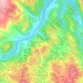
Name: Badamalos topographic map, elevation, terrain.
Average elevation: 724 m
Minimum elevation: 642 m
Maximum elevation: 829 m
Make a donation
Gear up for your next adventure:
As an Amazon Associate, this site earns from qualifying purchases at no extra cost to you.
Other topographic maps
Click on a map to view its topography, its elevation and its terrain.
Barragem
Portugal > Guarda > Aldeia da Ribeira, Vilar Maior e Badamalos > Batocas
Average elevation: 825 m
Aldeia da Ribeira
Portugal > Guarda > Aldeia da Ribeira, Vilar Maior e Badamalos
Average elevation: 816 m
Aldeia da Ribeira
Portugal > Guarda > Aldeia da Ribeira, Vilar Maior e Badamalos
Average elevation: 816 m
Make a donation
Gear up for your next adventure:
As an Amazon Associate, this site earns from qualifying purchases at no extra cost to you.