
Make a donation
Gear up for your next adventure:
As an Amazon Associate, this site earns from qualifying purchases at no extra cost to you.
Veyrins topographic map
Click on the map to display elevation.
Make a donation
Gear up for your next adventure:
As an Amazon Associate, this site earns from qualifying purchases at no extra cost to you.
About this map
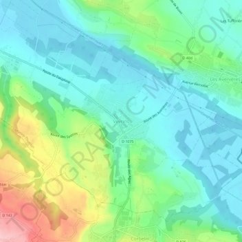
Name: Veyrins topographic map, elevation, terrain.
Average elevation: 252 m
Minimum elevation: 206 m
Maximum elevation: 373 m
Make a donation
Gear up for your next adventure:
As an Amazon Associate, this site earns from qualifying purchases at no extra cost to you.
Other topographic maps
Click on a map to view its topography, its elevation and its terrain.
Les Avenières
France > Auvergne-Rhône-Alpes > Isère > Les Avenières Veyrins-Thuellin
La ville « Les Avenières » se situe sur une butte avec des altitudes allant de 200 mètres à 289 mètres, permettant d'offrir une vue remarquable sur les monts du Bugey au nord, la plaine du Bouchage-Morestel à l'ouest, la Chartreuse, la Dent du Chat au loin à l'est et enfin couronnant l'horizon, les…
Average elevation: 233 m
Veyrins-Thuellin
France > Auvergne-Rhône-Alpes > Isère > Les Avenières Veyrins-Thuellin
Average elevation: 259 m