
Make a donation
Gear up for your next adventure:
As an Amazon Associate, this site earns from qualifying purchases at no extra cost to you.
Badenhausen topographic map
Click on the map to display elevation.
Make a donation
Gear up for your next adventure:
As an Amazon Associate, this site earns from qualifying purchases at no extra cost to you.
About this map
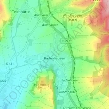
Name: Badenhausen topographic map, elevation, terrain.
Average elevation: 210 m
Minimum elevation: 153 m
Maximum elevation: 338 m
Make a donation
Gear up for your next adventure:
As an Amazon Associate, this site earns from qualifying purchases at no extra cost to you.
Other topographic maps
Click on a map to view its topography, its elevation and its terrain.
Bergstadt Bad Grund (Harz)
Deutschland > Niedersachsen > Landkreis Göttingen > Bad Grund
Die heutige Ortschaft Bergstadt Bad Grund (Harz) ist die älteste der sieben Oberharzer Bergstädte. Die Stadt wurde 1317 erstmals urkundlich als Forstort erwähnt. Um 1450 hatte sich die Siedlung bereits zum Berg- und Hüttenort des Erzbergbaus entwickelt. Herzog Heinrich der Jüngere verlieh dem Ort 1524 die…
Average elevation: 379 m