
Targanice topographic map
Interactive map
Click on the map to display elevation.
About this map
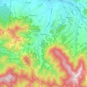
Name: Targanice topographic map, elevation, terrain.
Average elevation: 542 m
Minimum elevation: 339 m
Maximum elevation: 883 m
Other topographic maps
Click on a map to view its topography, its elevation and its terrain.
Andrychów
Poland > Lesser Poland Voivodeship > Wadowice County
Andrychów, gmina Andrychów, Wadowice County, Lesser Poland Voivodeship, 34-120, Poland
Average elevation: 347 m