
Thank you for supporting this site ❤️
Make a donation
Make a donation
Gear up for your next adventure:
As an Amazon Associate, this site earns from qualifying purchases at no extra cost to you.
Zunterkopf topographic map
Click on the map to display elevation.
Thank you for supporting this site ❤️
Make a donation
Make a donation
Gear up for your next adventure:
As an Amazon Associate, this site earns from qualifying purchases at no extra cost to you.
About this map
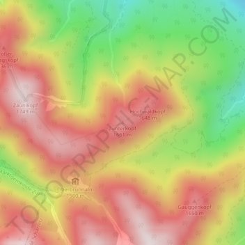
Name: Zunterkopf topographic map, elevation, terrain.
Average elevation: 1,451 m
Minimum elevation: 1,078 m
Maximum elevation: 1,738 m
Thank you for supporting this site ❤️
Make a donation
Make a donation
Gear up for your next adventure:
As an Amazon Associate, this site earns from qualifying purchases at no extra cost to you.
Other topographic maps
Click on a map to view its topography, its elevation and its terrain.
Arnspitzgruppe
Österreich > Tirol > Bezirk Innsbruck-Land > Gemeinde Scharnitz
Average elevation: 1,324 m