
Make a donation
Gear up for your next adventure:
As an Amazon Associate, this site earns from qualifying purchases at no extra cost to you.
Sorsum topographic map
Click on the map to display elevation.
Make a donation
Gear up for your next adventure:
As an Amazon Associate, this site earns from qualifying purchases at no extra cost to you.
About this map
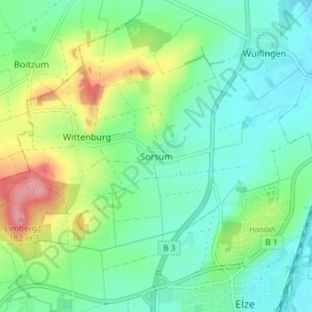
Name: Sorsum topographic map, elevation, terrain.
Average elevation: 101 m
Minimum elevation: 70 m
Maximum elevation: 175 m
Make a donation
Gear up for your next adventure:
As an Amazon Associate, this site earns from qualifying purchases at no extra cost to you.
Other topographic maps
Click on a map to view its topography, its elevation and its terrain.
Wülfingen
Deutschland > Niedersachsen > Landkreis Hildesheim > Elze
Auf leichten Anhöhen oberhalb der Haller und Leine entstanden die Ortschaften Hardingsen und Wülfingen in der Nähe der „Alten Heerstraße“. Die Zuwegung zur „Alten Heerstraße“ erfolgte von Wülfingen über den „Holzweg“ zum Hohlweg an der „Helle“, durch den die „Alte Heerstraße“…
Average elevation: 82 m