
Cuvéry topographic map
Interactive map
Click on the map to display elevation.
About this map
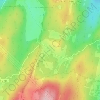
Name: Cuvéry topographic map, elevation, terrain.
Average elevation: 1,183 m
Minimum elevation: 1,080 m
Maximum elevation: 1,298 m
Other topographic maps
Click on a map to view its topography, its elevation and its terrain.
Le Raimont
France > Auvergne-Rhône-Alpes > Ain > Valserhône > Châtillon-en-Michaille > Ochiaz
Le Raimont, Ochiaz, Châtillon-en-Michaille, Valserhône, Nantua, Ain, Auvergne-Rhône-Alpes, France métropolitaine, 01200, France
Average elevation: 1,179 m