
Thank you for supporting this site ❤️
Make a donation
Make a donation
Gear up for your next adventure:
As an Amazon Associate, this site earns from qualifying purchases at no extra cost to you.
Les Maures topographic map
Click on the map to display elevation.
Thank you for supporting this site ❤️
Make a donation
Make a donation
Gear up for your next adventure:
As an Amazon Associate, this site earns from qualifying purchases at no extra cost to you.
About this map
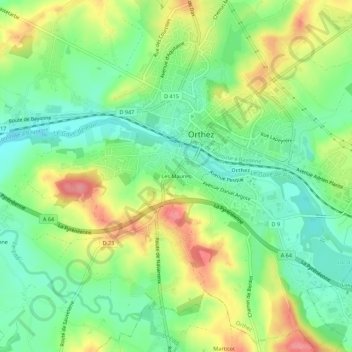
Name: Les Maures topographic map, elevation, terrain.
Average elevation: 84 m
Minimum elevation: 46 m
Maximum elevation: 139 m
Thank you for supporting this site ❤️
Make a donation
Make a donation
Gear up for your next adventure:
As an Amazon Associate, this site earns from qualifying purchases at no extra cost to you.
Other topographic maps
Click on a map to view its topography, its elevation and its terrain.
Sainte-Suzanne
France > Nouvelle-Aquitaine > Pyrénées-Atlantiques > Orthez
Agoès est un hameau, référencé dans le dictionnaire topographique Béarn-Pays basque de 1863 comme une annexe de Betbéder, autre hameau de Sainte-Suzanne.
Average elevation: 93 m