
Augusta topographic map
Click on the map to display elevation.
Augusta
As with the rest of the state, Augusta has a humid subtropical climate (Köppen Cfa), with short, mild winters, very hot, humid summers, and a wide diurnal temperature variation throughout much of the year, despite its low elevation and moisture. The monthly daily average temperature ranges from 45.4 °F (7.4 °C) in January to 81.6 °F (27.6 °C) in July; there are 53 nights with the low reaching the freezing mark, 82 days reaching or exceeding 90 °F (32 °C), and 5.5 days reaching 100 °F (38 °C) annually. Extreme temperatures range from −1 °F (−18 °C) on January 21, 1985 up to 108 °F (42 °C) on August 10, 2007 and August 21, 1983. Snowfall is not nearly as common as in Atlanta, due largely to Augusta's elevation, with downtown Augusta being about 900 ft (270 m) lower than downtown Atlanta. Freezing rain is also a threat in wintertime.
About this map
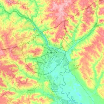
Name: Augusta topographic map, elevation, terrain.
Location: Augusta, Richmond County, Georgia, 30901, United States (33.31097 -82.13484 33.63097 -81.81484)
Average elevation: 90 m
Minimum elevation: 25 m
Maximum elevation: 180 m