Geolocate

Waena topographic map

Click on the map to display elevation.

About this map

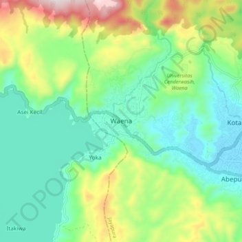
Name: Waena topographic map, elevation, terrain.

Location: Waena, Jayapura, Papua, Western New Guinea, 99351, Indonesia (-2.63693 140.59544 -2.55693 140.67544)

Average elevation: 196 m

Minimum elevation: 5 m

Maximum elevation: 639 m

Gear up for your next adventure:

🔦LED Headtorch - Bright and durable light for night activities
💡Solar Camping Lamp - Eco-friendly lighting for campsites
🧥Thermal Layer - Insulating layer for cold outdoor conditions
🧭GPS Tracker - Track your location in remote areas safely
🧦Hiking Liner Socks - Thin base layer to prevent friction and blisters

As an Amazon Associate, this site earns from qualifying purchases at no extra cost to you.