
Town of Vestal topographic map
Interactive map
Click on the map to display elevation.
About this map
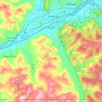
Name: Town of Vestal topographic map, elevation, terrain.
Location: Town of Vestal, Broome County, New York, United States (41.99890 -76.10900 42.11503 -75.94508)
Average elevation: 372 m
Minimum elevation: 241 m
Maximum elevation: 567 m
Other topographic maps
Click on a map to view its topography, its elevation and its terrain.
Town of Colesville
United States > New York > Broome County
Town of Colesville, Broome County, New York, United States
Average elevation: 413 m
Town of Conklin
United States > New York > Broome County
Town of Conklin, Town of Binghamton, Broome County, New York, United States
Average elevation: 381 m
City of Binghamton
United States > New York > Broome County
City of Binghamton, Dickinson, Broome County, New York, 13905, United States
Average elevation: 321 m