Geolocate

Rosario topographic map

Click on the map to display elevation.

About this map

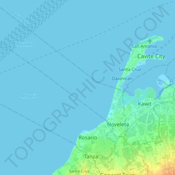
Name: Rosario topographic map, elevation, terrain.

Location: Rosario, Cavite, Calabarzon, 4106, Philippines (14.39907 120.73084 14.51575 120.87835)

Average elevation: 3 m

Minimum elevation: -2 m

Maximum elevation: 28 m

Other topographic maps

Click on a map to view its topography, its elevation and its terrain.

Bacoor

Philippines > Cavite > Bacoor

Average elevation: 26 m

Molino Dam

Philippines > Cavite > Bacoor

Average elevation: 37 m

Pooc II

Philippines > Cavite

Average elevation: 350 m

Bucana

Philippines > Cavite > Ternate

Average elevation: 21 m

Marahan I

Philippines > Cavite > Alfonso

Average elevation: 417 m

Balite II

Philippines > Cavite > Silang

Average elevation: 399 m

Bacoor River

Philippines > Cavite > Bacoor

Average elevation: 8 m

Limbon

Philippines > Cavite > Indang

Average elevation: 316 m

Aniban 1

Philippines > Cavite > Bacoor > Aniban 1

Average elevation: 7 m

Asisan

Philippines > Cavite > Tagaytay

Average elevation: 526 m

Gear up for your next adventure:

Lightweight Camping Tent - Portable shelter optimized for Canadian backcountry camping
🥾Light Trekking Boots - Supportive boots for multi-day treks
🧥Packable Rain Jacket - Breathable waterproof layer for unpredictable weather
🏕️Camping Hammock - Integrated protection for sleeping between trees
🧥Waterproof Hiking Jacket - Protect yourself from rain and wind while hiking

As an Amazon Associate, this site earns from qualifying purchases at no extra cost to you.