Geolocate

Sieiro topographic map

Click on the map to display elevation.

About this map

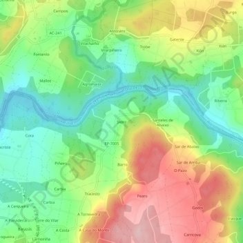
Name: Sieiro topographic map, elevation, terrain.

Location: Sieiro, Cora, A Estrada, Tabeirós - Tierra de Montes, Pontevedra, Galicia, 36683, España (42.73135 -8.52653 42.77135 -8.48653)

Average elevation: 113 m

Minimum elevation: 28 m

Maximum elevation: 229 m

Other topographic maps

Click on a map to view its topography, its elevation and its terrain.

Vea

España > Galicia > Tabeirós - Tierra de Montes > A Estrada

Average elevation: 195 m

Gear up for your next adventure:

🪜Heavy Duty Carabiners - Multi-use clips for securing gear to your backpack
🪑Ultralight Camping Stool - Compact seating for rest stops during long hikes
🥾Hiking Leggings - Comfortable leggings for outdoor activities
🥾Hiking Shorts - Breathable shorts suitable for summer hikes
🧢Sun Protection Cap - Breathable cap to protect from sun exposure

As an Amazon Associate, this site earns from qualifying purchases at no extra cost to you.