
Make a donation
Gear up for your next adventure:
As an Amazon Associate, this site earns from qualifying purchases at no extra cost to you.
Bergfelden topographic map
Click on the map to display elevation.
Make a donation
Gear up for your next adventure:
As an Amazon Associate, this site earns from qualifying purchases at no extra cost to you.
Bergfelden
Bergfelden liegt knapp fünf Kilometer östlich der Stadt Sulz am Neckar, im oberen Mühlbachtal am Fuße des Dickebergs. Der Ort liegt auf einer Höhe von 490 m ü. NN und hat ca. 1700 Einwohner (Stand 2015).
Make a donation
Gear up for your next adventure:
As an Amazon Associate, this site earns from qualifying purchases at no extra cost to you.
About this map
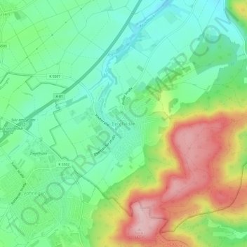
Name: Bergfelden topographic map, elevation, terrain.
Average elevation: 530 m
Minimum elevation: 445 m
Maximum elevation: 680 m
Make a donation
Gear up for your next adventure:
As an Amazon Associate, this site earns from qualifying purchases at no extra cost to you.
Other topographic maps
Click on a map to view its topography, its elevation and its terrain.
Bergfelden
Deutschland > Baden-Württemberg > Landkreis Rottweil > Sulz am Neckar
Bergfelden liegt knapp fünf Kilometer östlich der Stadt Sulz am Neckar, im oberen Mühlbachtal am Fuße des Dickebergs. Der Ort liegt auf einer Höhe von 490 m ü. NN und hat ca. 1700 Einwohner (Stand 2015).
Average elevation: 528 m
Holzhausen
Deutschland > Baden-Württemberg > Landkreis Rottweil > Sulz am Neckar
Average elevation: 501 m
Make a donation
Gear up for your next adventure:
As an Amazon Associate, this site earns from qualifying purchases at no extra cost to you.
Dürrenmettstetten
Deutschland > Baden-Württemberg > Landkreis Rottweil > Sulz am Neckar
Average elevation: 627 m