
Make a donation
Gear up for your next adventure:
As an Amazon Associate, this site earns from qualifying purchases at no extra cost to you.
New Eagle topographic map
Click on the map to display elevation.
Make a donation
Gear up for your next adventure:
As an Amazon Associate, this site earns from qualifying purchases at no extra cost to you.
About this map
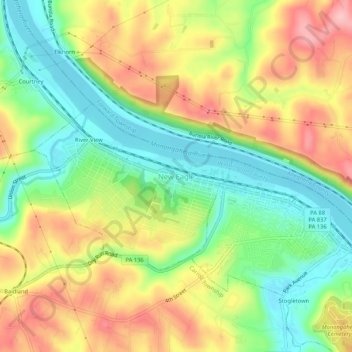
Name: New Eagle topographic map, elevation, terrain.
Location: New Eagle, Washington County, Pennsylvania, United States (40.18785 -79.96699 40.22785 -79.92699)
Average elevation: 290 m
Minimum elevation: 221 m
Maximum elevation: 371 m
Make a donation
Gear up for your next adventure:
As an Amazon Associate, this site earns from qualifying purchases at no extra cost to you.
Other topographic maps
Click on a map to view its topography, its elevation and its terrain.
Make a donation
Gear up for your next adventure:
As an Amazon Associate, this site earns from qualifying purchases at no extra cost to you.
Lake Jo-Ann
United States > Pennsylvania > Washington County > Peters Township
Average elevation: 343 m
Make a donation
Gear up for your next adventure:
As an Amazon Associate, this site earns from qualifying purchases at no extra cost to you.
Mount Pleasant Township
United States > Pennsylvania > Washington County
The McGugin Tunnel is located at latitude - longitude coordinates of N 40.28674 and W -80.33173. The nearest major town is Hickory, Pennsylvania, where it passes under Pennsylvania Route 18. The tunnel is at an elevation of 1,263 feet (385 m).
Average elevation: 362 m
West Middletown
United States > Pennsylvania > Washington County > West Middletown
Average elevation: 361 m
Make a donation
Gear up for your next adventure:
As an Amazon Associate, this site earns from qualifying purchases at no extra cost to you.