
Marburg topographic map
Click on the map to display elevation.
About this map
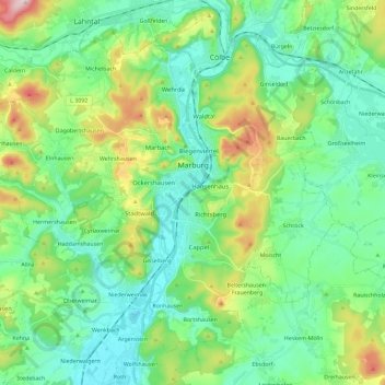
Name: Marburg topographic map, elevation, terrain.
Location: Marburg, Landkreis Marburg-Biedenkopf, Hesse, Germany (50.73803 8.62748 50.85873 8.85812)
Average elevation: 245 m
Minimum elevation: 163 m
Maximum elevation: 474 m
Other topographic maps
Click on a map to view its topography, its elevation and its terrain.
Aurorahütte
Germany > Hesse > Landkreis Marburg-Biedenkopf > Gladenbach > Erdhausen
Average elevation: 298 m