Geolocate

Taft topographic map

Click on the map to display elevation.

About this map

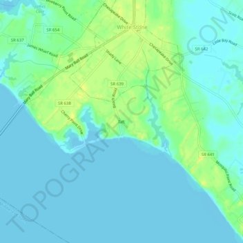
Name: Taft topographic map, elevation, terrain.

Location: Taft, Lancaster County, Virginia, 22578, United States (37.61285 -76.41135 37.65285 -76.37135)

Average elevation: 6 m

Minimum elevation: -1 m

Maximum elevation: 20 m

Other topographic maps

Click on a map to view its topography, its elevation and its terrain.

Irvington

United States > Virginia > Lancaster County

Average elevation: 7 m

Kilmarnock

United States > Virginia > Lancaster County

Average elevation: 16 m

Gear up for your next adventure:

🧢Beanie Hat - Keep your head warm in cold weather
🧶550 Survival Paracord - Versatile utility cord for emergency repairs and rigging
🥫Freeze-Dried Meals - Lightweight, high-calorie nutrition for multi-day treks
🧢Sun Hat - Wide-brim hat for sun protection
🧴Insect Repellent - Protect yourself from bugs during outdoor adventures

As an Amazon Associate, this site earns from qualifying purchases at no extra cost to you.