
Make a donation
Gear up for your next adventure:
As an Amazon Associate, this site earns from qualifying purchases at no extra cost to you.
Le Bel Aune topographic map
Click on the map to display elevation.
Make a donation
Gear up for your next adventure:
As an Amazon Associate, this site earns from qualifying purchases at no extra cost to you.
About this map
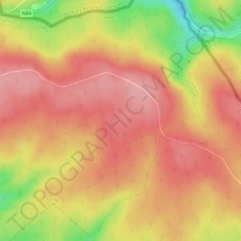
Name: Le Bel Aune topographic map, elevation, terrain.
Average elevation: 395 m
Minimum elevation: 314 m
Maximum elevation: 434 m
Make a donation
Gear up for your next adventure:
As an Amazon Associate, this site earns from qualifying purchases at no extra cost to you.
Other topographic maps
Click on a map to view its topography, its elevation and its terrain.
Bazeilles
France > Grand Est > Ardennes > Bazeilles
La Meuse, d'une longueur de 486 km, est un fleuve européen qui prend sa source en France, dans la commune du Châtelet-sur-Meuse, à 409 mètres d'altitude, et se jette dans la mer du Nord après un cours long d'approximativement 950 kilomètres traversant la France, la Belgique et les Pays-Bas. Elle…
Average elevation: 260 m