
Barrys Bay topographic map
Click on the map to display elevation.
About this map
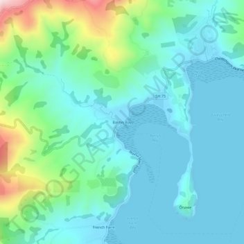
Name: Barrys Bay topographic map, elevation, terrain.
Average elevation: 100 m
Minimum elevation: -1 m
Maximum elevation: 499 m
Other topographic maps
Click on a map to view its topography, its elevation and its terrain.
Pigeon Bay
New Zealand > Canterbury > Christchurch City > Banks Peninsula Community
Average elevation: 243 m
Port Levy
New Zealand > Canterbury > Christchurch City > Banks Peninsula Community
Average elevation: 249 m
Akaroa Marine Reserve
New Zealand > Canterbury > Christchurch City > Banks Peninsula Community
Average elevation: 62 m
Un named plug
New Zealand > Canterbury > Christchurch City > Banks Peninsula Community > Diamond Harbour
Average elevation: 164 m
Akaroa
New Zealand > Canterbury > Christchurch City > Banks Peninsula Community
Average elevation: 152 m
Akaroa
New Zealand > Canterbury > Christchurch City > Banks Peninsula Community
Average elevation: 191 m