
Make a donation
Gear up for your next adventure:
As an Amazon Associate, this site earns from qualifying purchases at no extra cost to you.
Atarau topographic map
Click on the map to display elevation.
Make a donation
Gear up for your next adventure:
As an Amazon Associate, this site earns from qualifying purchases at no extra cost to you.
About this map
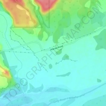
Name: Atarau topographic map, elevation, terrain.
Location: Atarau, Grey District, West Coast, 7843, New Zealand (-42.34835 171.48017 -42.32835 171.50017)
Average elevation: 59 m
Minimum elevation: 39 m
Maximum elevation: 121 m
Make a donation
Gear up for your next adventure:
As an Amazon Associate, this site earns from qualifying purchases at no extra cost to you.
Other topographic maps
Click on a map to view its topography, its elevation and its terrain.
Lake Brunner
New Zealand > West Coast > Grey District > Moana
Lake Brunner is the largest lake in the West Coast region, 10 km (6.2 mi) across with an area of 4061 ha, just over 40 km2 (15 sq mi). The outlet of the lake is the Arnold River, a tributary of the Grey River / Māwheranui, next to the largest settlement of Moana, on the north shore of the lake. The largest…
Average elevation: 168 m