Geolocate

Hautefort topographic map

Click on the map to display elevation.

About this map

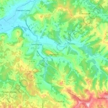
Name: Hautefort topographic map, elevation, terrain.

Location: Hautefort, Sarlat-la-Canéda, Dordogne, Nouvelle-Aquitaine, Metropolitan France, 24390, France (45.23050 1.08334 45.28926 1.19016)

Average elevation: 204 m

Minimum elevation: 134 m

Maximum elevation: 337 m

Other topographic maps

Click on a map to view its topography, its elevation and its terrain.

La Naussa

France > Nouvelle-Aquitaine > Dordogne > Chalais

Average elevation: 285 m

Le Clos de Barre

France > Nouvelle-Aquitaine > Dordogne > Sergeac

Average elevation: 148 m

Lascaux

France > Nouvelle-Aquitaine > Dordogne > Salon

Average elevation: 190 m

Cadouin

France > Nouvelle-Aquitaine > Dordogne

Average elevation: 191 m

Les Fosses

France > Nouvelle-Aquitaine > Dordogne > Les Eyzies

Average elevation: 121 m

Aillac

France > Nouvelle-Aquitaine > Dordogne > Carsac-Aillac

Average elevation: 125 m

Citole

France > Nouvelle-Aquitaine > Dordogne > Sadillac

Average elevation: 137 m

Gear up for your next adventure:

🔥Emergency Fire Starter - Reliable ignition source for all weather conditions
🛶Kayak Dry Bag - Waterproof storage for kayaking adventures
🔦LED Flashlight - Powerful and long-lasting flashlight for camping and emergencies
🧣Evaporative Cooling Towel - Beat the heat during intense summer climbs
🪜Heavy Duty Carabiners - Multi-use clips for securing gear to your backpack

As an Amazon Associate, this site earns from qualifying purchases at no extra cost to you.