Geolocate

Seguin topographic map

Click on the map to display elevation.

Seguin

The elevation at the courthouse is 522 feet (159 m) above mean sea level.

Wikipedia (CC-BY-SA 3.0)

About this map

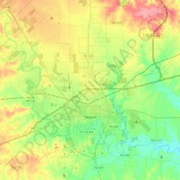
Name: Seguin topographic map, elevation, terrain.

Location: Seguin, Guadalupe County, Texas, United States (29.51199 -98.06061 29.68388 -97.83581)

Average elevation: 172 m

Minimum elevation: 128 m

Maximum elevation: 229 m

Other topographic maps

Click on a map to view its topography, its elevation and its terrain.

Haeckerville

United States > Texas > Guadalupe County > Cibolo

Average elevation: 213 m

Zorn

United States > Texas > Guadalupe County

Average elevation: 169 m

Gear up for your next adventure:

🥾Waterproof Trail Shoes - Shoes designed to handle wet terrain
🧢Outdoor Visor - Breathable visor for sunny hikes
💡Compact LED Flashlight - Powerful and portable flashlight for outdoor use
🥾Trail Hiking Socks - Comfortable socks to prevent blisters and fatigue
🛶Waterproof Dry Bags - Keep electronics and clothes dry during river crossings

As an Amazon Associate, this site earns from qualifying purchases at no extra cost to you.