Geolocate

Winesburg topographic map

Click on the map to display elevation.

About this map

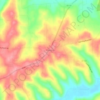
Name: Winesburg topographic map, elevation, terrain.

Location: Winesburg, Holmes County, Ohio, 44690, United States (40.59654 -81.71516 40.63654 -81.67516)

Average elevation: 358 m

Minimum elevation: 299 m

Maximum elevation: 403 m

Other topographic maps

Click on a map to view its topography, its elevation and its terrain.

Lake Buckhorn

United States > Ohio > Holmes County > Clark

Average elevation: 300 m

Holmesville

United States > Ohio > Holmes County

Average elevation: 262 m

Nashville

United States > Ohio > Holmes County

Average elevation: 363 m

Gear up for your next adventure:

🧦Outdoor Socks - Durable socks designed for hiking and outdoor sports
💧Hydration Pack - Hands-free hydration system for long hikes
🔭Compact Binoculars - Lightweight optics for scouting trails and wildlife
🧤Insulated Winter Gloves - Heavy-duty protection for sub-zero Canadian adventures
🥾Hiking Leggings - Comfortable leggings for outdoor activities

As an Amazon Associate, this site earns from qualifying purchases at no extra cost to you.