
鸿恩寺公园 topographic map
Interactive map
Click on the map to display elevation.
About this map
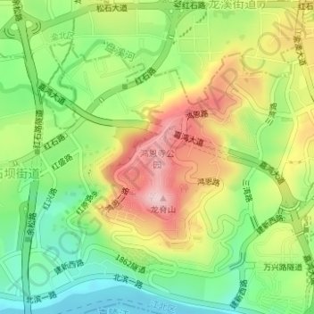
Name: 鸿恩寺公园 topographic map, elevation, terrain.
Location: 鸿恩寺公园, 大石坝街道, 江北区, 重庆市, 中国 (29.56751 106.50086 29.57819 106.51094)
Average elevation: 268 m
Minimum elevation: 158 m
Maximum elevation: 407 m
Other topographic maps
Click on a map to view its topography, its elevation and its terrain.