Geolocate

Pongor topographic map

Click on the map to display elevation.

About this map

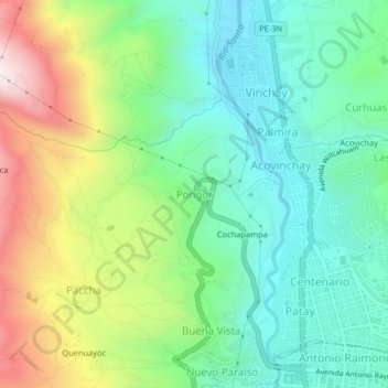
Name: Pongor topographic map, elevation, terrain.

Location: Pongor, Independencia, Huaraz, Áncash, 02690, Perú (-9.52770 -77.56434 -9.48770 -77.52434)

Average elevation: 3,209 m

Minimum elevation: 2,953 m

Maximum elevation: 3,724 m

Other topographic maps

Click on a map to view its topography, its elevation and its terrain.

Laguna Radian

Perú > Áncash > Independencia

Average elevation: 3,916 m

Laguna Llaca

Perú > Áncash > Independencia

Average elevation: 4,835 m

Río Paria

Perú > Áncash > Independencia > Las Lomas

Average elevation: 3,162 m

Gear up for your next adventure:

🧥Softshell Jacket - Windproof and breathable jacket for hiking
🔦LED Headtorch - Bright and durable light for night activities
🎒Fully Waterproof Backpack - Total protection for photography gear and electronics
💡Compact LED Flashlight - Powerful and portable flashlight for outdoor use
🔪Outdoor Multitool - Versatile tool for repairs and food prep in the wild

As an Amazon Associate, this site earns from qualifying purchases at no extra cost to you.