
Make a donation
Gear up for your next adventure:
As an Amazon Associate, this site earns from qualifying purchases at no extra cost to you.
Foster topographic map
Click on the map to display elevation.
Make a donation
Gear up for your next adventure:
As an Amazon Associate, this site earns from qualifying purchases at no extra cost to you.
About this map
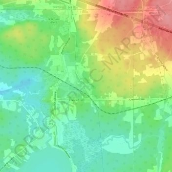
Name: Foster topographic map, elevation, terrain.
Average elevation: 219 m
Minimum elevation: 181 m
Maximum elevation: 279 m
Make a donation
Gear up for your next adventure:
As an Amazon Associate, this site earns from qualifying purchases at no extra cost to you.
Other topographic maps
Click on a map to view its topography, its elevation and its terrain.
Lac Brome
Canada > Québec > Brome-Missisquoi > Lac-Brome > Lac-Brome
Le lac Brome est situé au sud-est du Mont Brome ; il est la source de la rivière Yamaska. Sa superficie est de 14.53 km², son altitude est de 193 mètres et sa profondeur maximale est de 13 mètres. Sa longueur est de 5.5 km et sa largeur est de 5 km. Les Monts Sutton sont situés au sud et à l'est du lac.
Average elevation: 208 m