Geolocate

Pimpalwadi topographic map

Click on the map to display elevation.

About this map

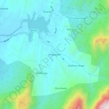
Name: Pimpalwadi topographic map, elevation, terrain.

Location: Pimpalwadi, Panvel, Raigad, Maharashtra, India (19.00141 73.23276 19.04141 73.27276)

Average elevation: 198 m

Minimum elevation: 63 m

Maximum elevation: 777 m

Other topographic maps

Click on a map to view its topography, its elevation and its terrain.

Patalganga

India > Maharashtra > Panvel

Average elevation: 13 m

Patalganga

India > Maharashtra > Panvel > Apta

Average elevation: 85 m

Gear up for your next adventure:

🩹Moleskin Blister Pads - Direct protection for painful foot pressure points
🥾Trail Hiking Shoes - Durable shoes designed for rugged trails
🧥Thermal Fleece Jacket - Versatile insulation for changing mountain temperatures
💡Portable Camping Lamp - Rechargeable lamp for campsite lighting
🥘Camping Cookware Set - Compact nesting pots and pans for trail cooking

As an Amazon Associate, this site earns from qualifying purchases at no extra cost to you.