Naggar topographic map
Interactive map
Click on the map to display elevation.
About this map
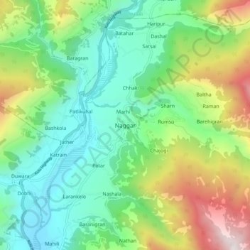
Name: Naggar topographic map, elevation, terrain.
Location: Naggar, Kullu, Kullu District, Himachal Pradesh, 175130, India (32.07325 77.12400 32.15325 77.20400)
Average elevation: 2,042 m
Minimum elevation: 1,379 m
Maximum elevation: 3,497 m
Other topographic maps
Click on a map to view its topography, its elevation and its terrain.
Brahman Koti
India > Himachal Pradesh > Kullu > Naggar
Brahman Koti, Naggar, Kullu, Himachal Pradesh, 175130, India
Average elevation: 1,774 m
Tosh
India > Himachal Pradesh > Kullu > Tosh
Tosh, Kullu, Himachal Pradesh, India
Average elevation: 2,710 m
Goj
India > Himachal Pradesh > Kullu > Manikaran
Goj, Manikaran, Kullu, Himachal Pradesh, 175105, India
Average elevation: 2,176 m
Manikaran
India > Himachal Pradesh > Kullu
Manikaran, Kullu, Kullu District, Himachal Pradesh, 175105, India
Average elevation: 2,641 m