Geolocate

Rastislavice topographic map

Click on the map to display elevation.

Rastislavice

The village lies at an altitude of 124 metres and covers an area of 19.589 km². It has a population of about 920 people.

Wikipedia (CC-BY-SA 3.0)

About this map

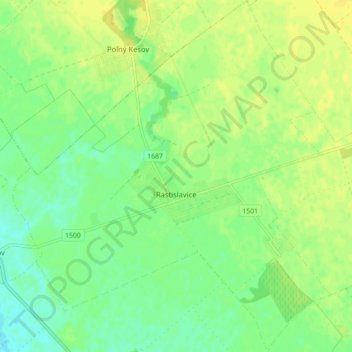
Name: Rastislavice topographic map, elevation, terrain.

Location: Rastislavice, District of Nové Zámky, Region of Nitra, Western Slovakia, 941 08, Slovakia (48.11164 18.03247 48.17058 18.11216)

Average elevation: 125 m

Minimum elevation: 114 m

Maximum elevation: 134 m

Gear up for your next adventure:

💧Reusable Water Bottle - Durable water bottles for hydration on trails
🧳Compression Sacks - Maximize space in your backpack by shrinking gear
🥾Mountaineering Boots - Supportive boots for climbing and high-altitude hiking
🧥Insulated Jacket - Keep warm in cold outdoor conditions
👟Trail Running Shoes - Agile footwear for fast-paced topographic exploration

As an Amazon Associate, this site earns from qualifying purchases at no extra cost to you.