
Make a donation
Gear up for your next adventure:
As an Amazon Associate, this site earns from qualifying purchases at no extra cost to you.
Isla Tenglo topographic map
Click on the map to display elevation.
Make a donation
Gear up for your next adventure:
As an Amazon Associate, this site earns from qualifying purchases at no extra cost to you.
About this map
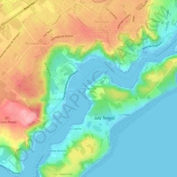
Name: Isla Tenglo topographic map, elevation, terrain.
Average elevation: 48 m
Minimum elevation: -3 m
Maximum elevation: 136 m
Make a donation
Gear up for your next adventure:
As an Amazon Associate, this site earns from qualifying purchases at no extra cost to you.
Other topographic maps
Click on a map to view its topography, its elevation and its terrain.
Río Gato
Chile > Región de Los Lagos > Provincia de Llanquihue > Puerto Montt > El Gato
Average elevation: 31 m
Parque Nacional Alerce Andino
Chile > Región de Los Lagos > Provincia de Llanquihue > Puerto Montt
Average elevation: 559 m
Humedal Urbano Parque Mirasol
Chile > Región de Los Lagos > Provincia de Llanquihue > Puerto Montt
Average elevation: 92 m
Estero Avellano
Chile > Región de Los Lagos > Provincia de Llanquihue > Puerto Montt > Alerce
Average elevation: 106 m
Make a donation
Gear up for your next adventure:
As an Amazon Associate, this site earns from qualifying purchases at no extra cost to you.