
Thank you for supporting this site ❤️
Make a donation
Make a donation
Gear up for your next adventure:
As an Amazon Associate, this site earns from qualifying purchases at no extra cost to you.
Lokeren topographic map
Click on the map to display elevation.
Thank you for supporting this site ❤️
Make a donation
Make a donation
Gear up for your next adventure:
As an Amazon Associate, this site earns from qualifying purchases at no extra cost to you.
About this map
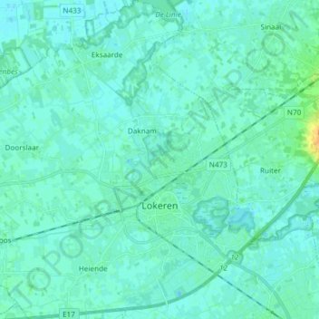
Name: Lokeren topographic map, elevation, terrain.
Location: Lokeren, Sint-Niklaas, East Flanders, Flanders, 9160, Belgium (51.07129 3.89665 51.16467 4.03397)
Average elevation: 4 m
Minimum elevation: -2 m
Maximum elevation: 27 m
Thank you for supporting this site ❤️
Make a donation
Make a donation
Gear up for your next adventure:
As an Amazon Associate, this site earns from qualifying purchases at no extra cost to you.