Geolocate

Wahoo topographic map

Click on the map to display elevation.

About this map

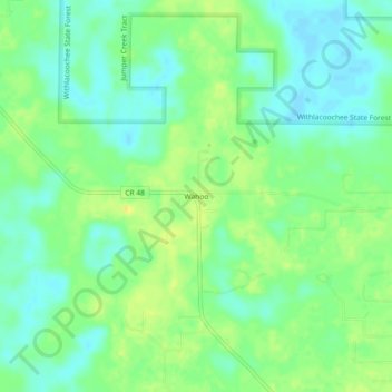
Name: Wahoo topographic map, elevation, terrain.

Location: Wahoo, Sumter County, Florida, 33513, United States (28.67055 -82.21564 28.71055 -82.17564)

Average elevation: 14 m

Minimum elevation: 3 m

Maximum elevation: 26 m

Gear up for your next adventure:

🔭Compact Binoculars - Lightweight optics for scouting trails and wildlife
🛰️Satellite Messenger - Emergency communication for areas with no cell service
👟Sport Hiking Sandals - Breathable footwear for water crossings and camp rest
👖Convertible Hiking Pants - Zip-off legs to adapt to changing weather conditions
💧Reusable Water Bottle - Durable water bottles for hydration on trails

As an Amazon Associate, this site earns from qualifying purchases at no extra cost to you.