Geolocate

Pasadeña topographic map

Click on the map to display elevation.

About this map

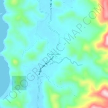
Name: Pasadeña topographic map, elevation, terrain.

Location: Pasadeña, El Nido, Palawan, Mimaropa, Philippines (11.24730 119.41732 11.28730 119.45732)

Average elevation: 67 m

Minimum elevation: 0 m

Maximum elevation: 328 m

Other topographic maps

Click on a map to view its topography, its elevation and its terrain.

Miniloc Island

Philippines > Palawan > El Nido

Average elevation: 27 m

Shimizu Island

Philippines > Palawan > El Nido

Average elevation: 18 m

South Guntao Island

Philippines > Palawan > El Nido

Average elevation: 7 m

Nacpan Beach

Philippines > Palawan > El Nido > Calitang

Average elevation: 36 m

Lio Beach

Philippines > Palawan > El Nido > Villa Libertad

Average elevation: 13 m

Gear up for your next adventure:

Backpacking Tent - Lightweight tent for long-distance hiking trips
Tent Footprint - Protect tent floor and increase durability
🥘Camping Cookware Set - Compact nesting pots and pans for trail cooking
🛏️Sleeping Bag - Warm and compact sleeping bags for outdoor camping
🕯️Camping Lantern - Illuminates your entire campsite with high-efficiency LEDs

As an Amazon Associate, this site earns from qualifying purchases at no extra cost to you.