
Thank you for supporting this site ❤️
Make a donation
Make a donation
Gear up for your next adventure:
As an Amazon Associate, this site earns from qualifying purchases at no extra cost to you.
Piller topographic map
Click on the map to display elevation.
Thank you for supporting this site ❤️
Make a donation
Make a donation
Gear up for your next adventure:
As an Amazon Associate, this site earns from qualifying purchases at no extra cost to you.
About this map
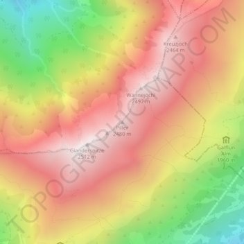
Name: Piller topographic map, elevation, terrain.
Location: Piller, Fließ, Bezirk Landeck, 6491, Austria (47.15100 10.66730 47.15110 10.66740)
Average elevation: 2,064 m
Minimum elevation: 1,443 m
Maximum elevation: 2,506 m
Thank you for supporting this site ❤️
Make a donation
Make a donation
Gear up for your next adventure:
As an Amazon Associate, this site earns from qualifying purchases at no extra cost to you.