
Pickering topographic map
Click on the map to display elevation.
Pickering
The city covers an area of 231 square kilometres (89 sq mi) with an elevation of 89 metres (292 ft).
About this map
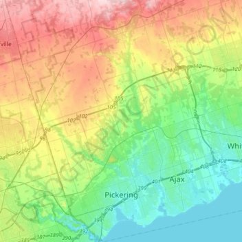
Name: Pickering topographic map, elevation, terrain.
Location: Pickering, Durham Region, Golden Horseshoe, Ontario, Canada (43.79307 -79.22004 44.01076 -79.00859)
Average elevation: 170 m
Minimum elevation: 72 m
Maximum elevation: 351 m
Durham Region trails, hiking, mountain biking, running and outdoor activities
Other topographic maps
Click on a map to view its topography, its elevation and its terrain.
Darlington Provincial Park
Canada > Ontario > Durham Region > Clarington
Darlington Provincial Park is a provincial park in Ontario, Canada. It is located just south of Highway 401 in the city of Bowmanville. A small park, the topography is dominated by gentle hills formed by a terminal moraine deposited by glaciers at the end of the last Ice Age. The park borders on the northern…
Average elevation: 84 m