
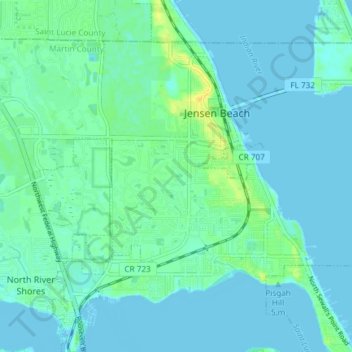
Jensen Beach topographic map
Click on the map to display elevation.
Jensen Beach
The Skyline Drive area includes some of the highest points in the community, reaching an elevation of 70 feet (21 m) at one point.
About this map
Name: Jensen Beach topographic map, elevation, terrain.
Location: Jensen Beach, Martin County, Florida, 34957, United States (27.21228 -80.28410 27.26385 -80.20981)
Average elevation: 5 m
Minimum elevation: -3 m
Maximum elevation: 21 m
Other topographic maps
Click on a map to view its topography, its elevation and its terrain.
Jensen Beach
United States > Florida > Martin County > Jensen Beach
The Skyline Drive area includes some of the highest points in the community, reaching an elevation of 70 feet (21 m) at one point.
Average elevation: 5 m
Jensen Beach
United States > Florida > Martin County > Jensen Beach
The Skyline Drive area includes some of the highest points in the community, reaching an elevation of 70 feet (21 m) at one point.
Average elevation: 5 m