Geolocate

Wenceslao topographic map

Click on the map to display elevation.

About this map

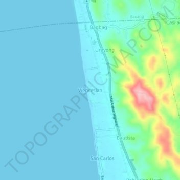
Name: Wenceslao topographic map, elevation, terrain.

Location: Wenceslao, Caba, La Union, Ilocos Region, 2502, Philippines (16.43522 120.31277 16.47522 120.35277)

Average elevation: 27 m

Minimum elevation: 0 m

Maximum elevation: 168 m

Gear up for your next adventure:

💧Reusable Water Bottle - Durable water bottles for hydration on trails
🏃Hydration Running Vest - Carry water and maps close to your body for speed
👟Trail Running Shoes - Agile footwear for fast-paced topographic exploration
🧭GPS Tracker - Track your location in remote areas safely
🧥Ultralight Puffy Jacket - Maximum warmth that packs down to the size of an orange

As an Amazon Associate, this site earns from qualifying purchases at no extra cost to you.