
Make a donation
Gear up for your next adventure:
As an Amazon Associate, this site earns from qualifying purchases at no extra cost to you.
Wilkes-Barre topographic map
Click on the map to display elevation.
Make a donation
Gear up for your next adventure:
As an Amazon Associate, this site earns from qualifying purchases at no extra cost to you.
Wilkes-Barre
According to the U.S. Census Bureau, the city has a total area of 7.2 square miles (19 km2), of which 6.8 square miles (18 km2) is land and 0.3 square miles (0.78 km2), or 4.60%, is water. The city is bordered by the Susquehanna River to the west. Most of Downtown is located on a wide floodplain. Floodwalls were constructed to protect a large percentage of the city. The elevation of the downtown area is about 550 feet (170 m) above sea level. As you travel inland, away from the river, the elevation rises. Wilkes-Barre Mountain is a physical barrier southeast of the city.
Make a donation
Gear up for your next adventure:
As an Amazon Associate, this site earns from qualifying purchases at no extra cost to you.
About this map
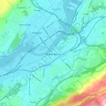
Name: Wilkes-Barre topographic map, elevation, terrain.
Location: Wilkes-Barre, Luzerne County, Pennsylvania, United States (41.22193 -75.92814 41.27292 -75.82685)
Average elevation: 218 m
Minimum elevation: 154 m
Maximum elevation: 574 m
Make a donation
Gear up for your next adventure:
As an Amazon Associate, this site earns from qualifying purchases at no extra cost to you.