
Make a donation
Gear up for your next adventure:
As an Amazon Associate, this site earns from qualifying purchases at no extra cost to you.
Garrotxa topographic map
Click on the map to display elevation.
Make a donation
Gear up for your next adventure:
As an Amazon Associate, this site earns from qualifying purchases at no extra cost to you.
Garrotxa
Im Zentrum des Kreises liegt auch der Naturschutzpark Vulkane der Garrotxa, eine Landschaft mit mehr als vierzig bewaldeten Vulkanen, deren Kraterränder zwischen 10 und 160 m in die Höhe ragen. Der Durchmesser der Krater variiert von 300 bis 1.500 m. Vor etwa 11.500 Jahren brach der Vulkan Croscat letztmals aus. 1985 wurde die Vulkanzone vom katalanischen Parlament zum Naturpark erklärt.
Make a donation
Gear up for your next adventure:
As an Amazon Associate, this site earns from qualifying purchases at no extra cost to you.
About this map
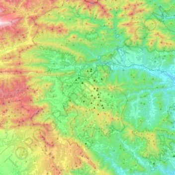
Name: Garrotxa topographic map, elevation, terrain.
Location: Garrotxa, Girona, Katalonien, Spanien (42.01213 2.33219 42.33407 2.77918)
Average elevation: 659 m
Minimum elevation: 120 m
Maximum elevation: 1,854 m
Make a donation
Gear up for your next adventure:
As an Amazon Associate, this site earns from qualifying purchases at no extra cost to you.