Geolocate

Davis City topographic map

Click on the map to display elevation.

About this map

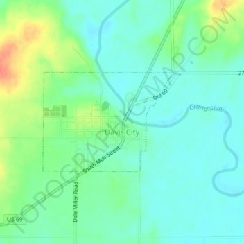
Name: Davis City topographic map, elevation, terrain.

Location: Davis City, Decatur County, Iowa, United States (40.63455 -93.82008 40.64552 -93.80122)

Average elevation: 281 m

Minimum elevation: 266 m

Maximum elevation: 315 m

Gear up for your next adventure:

🦶Anti-Blister Balm - Prevents friction and hotspots during long ascents
🧰Emergency Multi-Tool - Compact multi-tool for outdoor survival
🧭Orienteering Kit - Tools for map reading and navigation in the wild
🥾Trail Running Boots - Durable shoes designed for trail running
🧥Ultralight Puffy Jacket - Maximum warmth that packs down to the size of an orange

As an Amazon Associate, this site earns from qualifying purchases at no extra cost to you.