Geolocate

Mulu topographic map

Click on the map to display elevation.

About this map

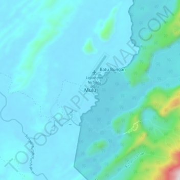
Name: Mulu topographic map, elevation, terrain.

Location: Mulu, Marudi, Miri Division, Sarawak, 98008, Malaysia (4.00439 114.76858 4.08439 114.84858)

Average elevation: 110 m

Minimum elevation: 12 m

Maximum elevation: 1,141 m

Other topographic maps

Click on a map to view its topography, its elevation and its terrain.

Tutoh River

Malaysia > Sarawak > Marudi

Average elevation: 51 m

Gunung Mulu National Park

Malaysia > Sarawak > Marudi

Average elevation: 460 m

Gear up for your next adventure:

🧥Softshell Hiking Jacket - The perfect balance of wind protection and breathability
🧴Outdoor Sunscreen - High SPF protection for high-altitude UV exposure
🐕Hiking Dog Pack - Let your canine companion carry their own water and food
🥾Light Hiking Boots - Lightweight and comfortable boots for day hikes
🥾Mountain Hiking Shoes - Shoes with superior grip for mountainous terrain

As an Amazon Associate, this site earns from qualifying purchases at no extra cost to you.